


Seoul is a city defined as much by its rivers as by its mountains and modern skyline. The Han River, which cuts through the heart of the South Korean capital from east to west, is spanned by more than 30 bridges, each serving not only as infrastructure but as cultural landmarks, recreational spaces, and symbols of Korea’s remarkable urban transformation. For students arriving to study in South Korea, discovering the bridges of Seoul is one of the most memorable experiences of settling into this dynamic city.
The Han River and Its Role in Seoul’s Urban Identity
The Han River, known in Korean as Hangang, stretches approximately 514 kilometers through the Korean Peninsula and passes through Seoul over a width that reaches up to one kilometer in the city center. The river has been central to Korean civilization for thousands of years, serving as a water source, transportation artery, and defensive boundary.
During the compressed economic growth of the 1960s through 1980s, known globally as the Miracle on the Han River, rapid industrialization and urbanization transformed both the riverbanks and the bridges crossing them. The bridges of Seoul today are a physical record of this transformation, ranging from utilitarian structures built during periods of postwar reconstruction to architecturally ambitious contemporary crossings built during periods of prosperity.
The Han River parks that line both banks of the river adjacent to the bridges have become some of Seoul’s most beloved public spaces, used for cycling, picnicking, water sports, and evening gatherings. Understanding the bridge network is inseparable from understanding Han River culture, which is a significant part of daily student life in Seoul.
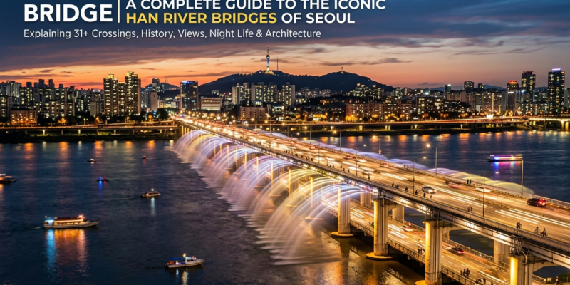
Banpo Bridge: The Rainbow Bridge of Seoul
Banpo Bridge is arguably the most famous bridge in Seoul and one of the most recognizable bridges in all of Asia. Located in the Seocho and Yongsan districts of central Seoul, Banpo Bridge is actually a double-decker structure. The upper deck carries the Olympic Expressway, a major arterial road, while the lower deck, known as Jamsu Bridge, serves as an additional traffic route that submerges during high water periods.
What makes Banpo Bridge internationally famous is its Moonlight Rainbow Fountain, a spectacular water feature installed along both sides of the bridge’s upper deck. The fountain system uses 380 nozzles on each side of the bridge, discharging water in graceful arcs toward the Han River below while LED lighting creates rainbow effects visible for considerable distances. The fountain operates during specific hours in evenings and attracts enormous crowds from both local and international visitors.
For Indian students living in the Gangnam or Seocho areas, Banpo Bridge and the adjacent Banpo Hangang Park represent an essential social destination, especially during the warmer months from spring through autumn.
Mapo Bridge: History, Renewal, and the Bridge of Life Project
Mapo Bridge holds a complicated and deeply humanistic place in Seoul’s urban story. For years, the bridge was associated with high rates of suicide, a reflection of social pressures in Korean society that gained international media attention. In response, Seoul Metropolitan Government in partnership with Samsung Life Insurance undertook the Bridge of Life project, transforming Mapo Bridge into a space designed to encourage connection and conversation.
The bridge railings were fitted with messages of hope, photographs representing life’s significant moments, and motion-activated displays that respond to pedestrians crossing on foot. Benches and rest areas were installed to encourage people to pause and engage with their surroundings. Telephone counseling connections were made available at intervals along the bridge.
The transformation of Mapo Bridge into a space of emotional support and public health advocacy is an example of how Seoul uses urban infrastructure to respond to social challenges. Understanding this context is meaningful for students engaged in social sciences, public health, urban planning, or psychological studies in South Korea.
Hangang Bridge: The Oldest Bridge in Seoul
Hangang Bridge, known historically as the first bridge built across the Han River in the modern era, holds enormous historical significance for Seoul. Construction of the original bridge began under Japanese colonial rule and was completed in 1917. The bridge was destroyed and rebuilt multiple times, most significantly during the Korean War in 1950 when retreating South Korean forces demolished it to slow the advance of North Korean troops.
The current Hangang Bridge is a two-part structure comprising two parallel bridges carrying traffic in opposite directions. It connects Dongjak in the south to Yongsan in the north and remains one of the busiest crossings over the Han River. The bridge’s historical weight makes it a reference point in Korean national memory.
For students interested in Korean history and cultural heritage, visiting Hangang Bridge and the nearby War Memorial of Korea provides important historical grounding for understanding modern South Korea.
Dongho Bridge and the East Seoul Riverside
Dongho Bridge connects the Seongdong and Gwangjin districts in the eastern part of Seoul. The bridge area is notable for the adjacent Ttukseom Hangang Park, one of the most popular recreational areas along the river’s northern bank. The park features swimming facilities open in summer, bicycle rentals, sports courts, and convenience stores catering to the large numbers of young Seoulites who gather at the riverside during warmer seasons.
Students attending universities in eastern Seoul, including Konkuk University and Sejong University located in the Gwangjin and Seongdong districts, frequently use Dongho Bridge as part of their daily commute and recreational routines.
Seongsu Bridge: A Bridge That Collapsed and Rebuilt Korean Infrastructure Standards
Seongsu Bridge gained tragic notoriety when it partially collapsed on October 21, 1994, during morning rush hour. The collapse resulted in 32 deaths and injuries to dozens more. The disaster exposed serious deficiencies in construction quality oversight and infrastructure maintenance that had accumulated during Korea’s rapid development decades.
The government response to the Seongsu Bridge collapse was comprehensive, initiating nationwide infrastructure audits, stricter construction regulations, and enhanced maintenance protocols for all major public structures. A new Seongsu Bridge was built and opened in 1997, incorporating significantly improved engineering standards.
The Seongsu Bridge collapse remains an important case study in civil engineering education and public policy, illustrating the social costs of prioritizing speed of development over construction quality. For students in engineering or urban planning programs at Korean universities, this historical event is often referenced in coursework.
Yanghwa Bridge and the Seonyudo Park Island
Yanghwa Bridge in western Seoul passes over Seonyudo Island, a small landmass in the Han River that has been transformed into one of Seoul’s most creative public parks. Seonyudo Park was converted from a former water treatment facility into an ecological garden and cultural space, with the industrial architecture of the old plant repurposed as exhibition spaces, outdoor theatres, and green corridors.
The island is accessible by a pedestrian bridge from both the northern and southern banks of the Han River, and the transformation of the Seonyudo site has received international recognition for its innovative approach to urban reuse and ecological restoration.
Yanghwa Bridge itself is a major road crossing carrying heavy traffic between northern and southern Seoul. The combination of industrial heritage, ecological park, and busy transport infrastructure makes this part of the Han River a uniquely layered urban environment.
Jamsil Bridge and the Olympic Legacy Area
Jamsil Bridge connects the Jamsil area of Songpa District in southern Seoul to the northern riverside, positioned near the Lotte World Tower, Jamsil Baseball Stadium, and the expansive Olympic Park built for the 1988 Seoul Summer Olympics. The bridge sits in an area that encapsulates modern Seoul’s ambitions in sports, entertainment, and urban density.
The 1988 Seoul Olympics were a transformational moment for South Korea’s international image and infrastructure. Many of the bridges, expressways, and riverside developments in Seoul were accelerated or directly built for the Olympics, and the Jamsil area remains the most visually dramatic demonstration of that legacy.
Bridges as Cultural and Social Spaces in Seoul
A distinctive feature of Seoul’s bridge culture is the way in which bridges and their adjacent riverside parks function as integrated social spaces rather than purely transit infrastructure. Seoul Metropolitan Government has invested substantially in riverside development, creating cycling paths that connect multiple Hangang parks beneath and alongside the bridge network.
The cycling path system along the Han River allows cyclists to travel from western Seoul near Gimpo to eastern Seoul near the Gwangjin area entirely along dedicated river paths passing under or adjacent to numerous bridges. This infrastructure is heavily used by students and residents for both commuting and leisure.
Food truck clusters, outdoor movie screenings, kayaking rental stations, and fitness zones have been established in riverside parks throughout the bridge network, making the Han River one of Seoul’s most socially active public spaces. For students adjusting to life in Seoul and seeking affordable, enriching leisure activities, the Han River parks represent an invaluable resource.
Korean cultural norms around outdoor recreation and group dining are well expressed in Han River park culture, where it is common to see groups spreading out convenience store meals on the grass or cycling in groups across multiple bridges. Understanding Korean social customs helps international students participate comfortably in these shared public spaces.
Getting Around Seoul’s Bridges as a Student
Seoul’s extensive public transportation network connects to most major bridges through subway stations located at or near bridge approaches on both the northern and southern banks. The Seoul Metropolitan Subway system includes stations that provide direct access to Banpo Bridge from Dongjak Station, Mapo Bridge from Mapo Station, and the Jamsil Bridge area from Jamsil Station.
Buses frequently use the major bridges as part of their cross-river routing, and the T-money card used on subway and buses throughout Seoul is also accepted on public bicycles available at stations near Han River parks.
For students planning routes to their universities, workplaces, or recreational destinations across the Han River, understanding the bridge geography simplifies navigation considerably. Mapping applications available in Korea such as Naver Map and KakaoMap provide detailed routing including bridge crossings.
Conclusion
The bridges of Seoul South Korea are far more than concrete and steel crossings over the Han River. They are expressions of the city’s history, its tragedies and recoveries, its capacity for innovation in public space, and its commitment to making urban infrastructure serve social and recreational needs alongside transport functions.
For Indian students arriving to study and live in Seoul, the bridges of the Han River and the parks that surround them represent some of the best free or low-cost experiences the city offers. Exploring them across different seasons is one of the most rewarding ways to develop a genuine connection with the city.
To learn more about preparing for life as a student in South Korea, including accommodation guidance, cultural orientation, and academic program information, visit studyinsouthkorea.in for resources designed specifically for Indian students choosing South Korea as their study destination.Share